High-Altitude Treks & Peak Profiles
* Panchachuli Peaks
This looks like a solid, well-structured foundation for a blog post. Since you are focusing on high-altitude peak profiles and trekking, the transition from factual data to travel advice is very smooth.
To ensure this content is ready for publication and remains highly unique, I’ve refined the flow and added some descriptive depth to the peak profiles and trekking sections below.
---
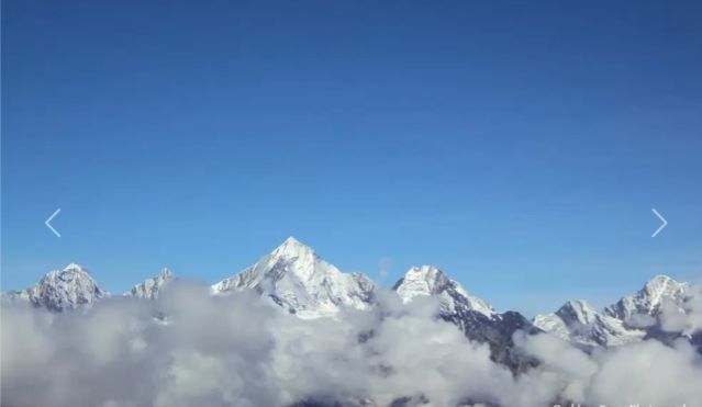
## The Sentinels of Kumaon: A Guide to the Panchachuli Peaks
The Panchachuli massif is a masterpiece of the Central Himalayas. Rising sharply from the Darma Valley in the Pithoragarh district, these five snow-shrouded summits serve as a dramatic partition between the Goriganga and Vedang valleys. Local lore gives the range its name—"The Five Chulhas" (cooking hearths)—where the Pandavas are said to have prepared their final earthly meal before their celestial ascent.
### The Five Peaks: A Profile
Each summit in the massif offers a distinct silhouette and a unique chapter in mountaineering history:
* Panchachuli I (6,355m): Standing as the northernmost sentry, this peak was first conquered in 1972 by an Indo-Tibetan Border Police team, marking the beginning of the massif's modern climbing era.
* Panchachuli II (6,904m): The undisputed monarch of the group. As the highest and most imposing peak, it demands immense technical prowess and remains the ultimate prize for alpinists in the region.
* Panchachuli III (6,312m): This peak is defined by its sharp, icy geometry. It resisted all attempts for nearly thirty years, finally seeing its first successful ascent in 2001.
* Panchachuli IV (6,334m): Known for its volatility, this peak is guarded by massive ice falls and a microclimate that can shift from clear to treacherous in minutes.
* Panchachuli V (6,437m): The southern anchor of the range. It was first summited in 1992 through a collaborative effort between Indian and British mountaineers.
---
### Journey to the Base: The Panchachuli Trek
For those who prefer to admire the heights from the ground, the trek to the base camp offers a world-class adventure through one of India's most remote corners.
* Timeframe: 7 to 9 days of immersive wilderness.
* Vertical Reach: You will touch altitudes of approximately 4,260 meters.
* Seasonality: The windows of April to June (for rhododendrons) and September to October (for crystal clarity) are ideal.
#### Route Highlights
* The Darma Valley: More than just a trail, this valley is a living museum of Bhotia culture, dotted with ancient stone villages and deep-rooted traditions.
* Biodiversity: The path transitions from the shade of ancient deodar and chestnut forests into the vast "Bugyals"—high-altitude meadows that transform into a vibrant carpet of wildflowers during the spring.
* The Meola Glacier: The trek’s grand finale. Standing at the edge of the glacier, the scale of the Panchachuli wall becomes hauntingly beautiful as it rises thousands of meters directly above you.
---
### Expert Insights for the Trail
* The Dantu Rule: Rapid elevation gain is the biggest challenge in Kumaon. Spending an extra acclimatization day in the village of Dantu isn't just a suggestion; it's the best way to ensure your body enjoys the trek as much as your eyes do.
* Border Formalities: Because of the proximity to the Tibet border, Inner Line Permits (ILP) are mandatory. These are best secured in advance at Dharchula or Pithoragarh.
* Fragile Beauty: The Darma Valley is an ecologically sensitive zone. Practicing "Leave No Trace" principles ensures that the Meola Glacier remains as pristine for the next generation as it is today.
---